The question of how borders were created is one of history’s most consequential stories. Today, the world contains 316 international land borders stretching approximately 154,000 miles across every continent. These lines determine citizenship, control the movement of people and goods, spark wars, and define national identities. Yet more than half of the world’s current borders did not even exist before the twentieth century, and less than one percent were established before 1500. Far from being ancient or natural, most of the boundaries on today’s maps are surprisingly recent — and often surprisingly arbitrary.
Understanding how borders were created means tracing a journey from the fluid tribal territories of the ancient world, through the empires of Rome and China, past the revolutionary Peace of Westphalia in 1648, into the colonial scrambles of the nineteenth century, and through the wars and treaties of the twentieth century that stamped the final shape onto the political map we use today. Moreover, the legacy of how borders were drawn continues to shape conflicts, migrations, and political tensions across every region of the world — from the disputed South China Sea to the unresolved frontiers of Africa.
Before Borders: The Ancient World Without Fixed Lines
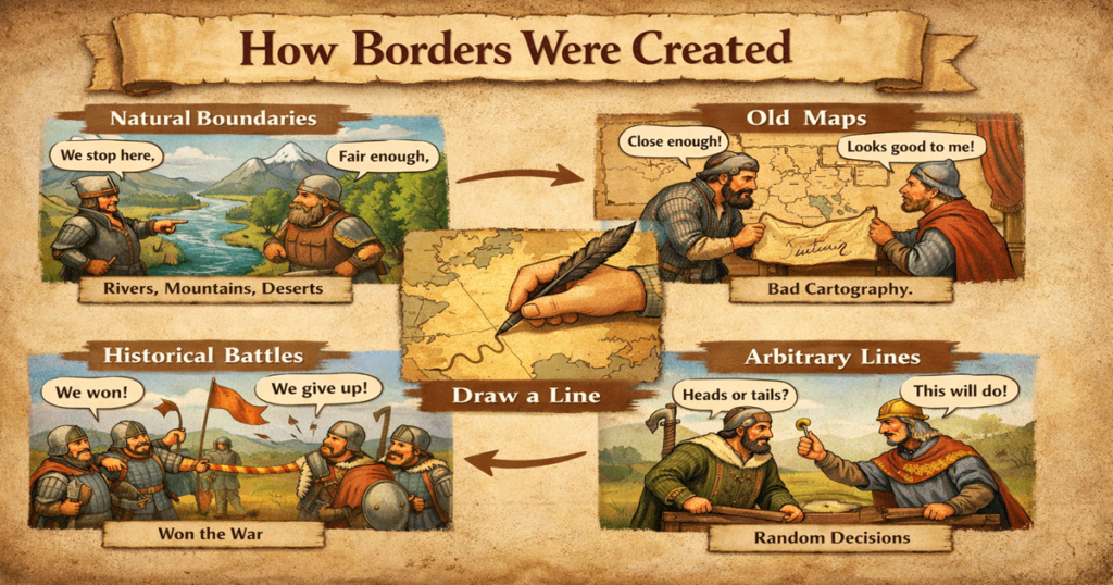
For most of human history, the concept of a fixed, precisely surveyed border between sovereign states simply did not exist. Ancient civilisations organised territory through zones of influence, natural barriers, and tribal custom rather than drawn lines on a map. Rivers, mountain ranges, deserts, and forests served as the primary boundaries between communities — not because anyone formally designated them as such, but because they presented practical obstacles to movement and communication.
The Roman Empire offers perhaps the clearest early example of territorial boundary-making. Up until the early seventeenth century, borders across the Roman Empire functioned primarily as administrative and economic outposts rather than militarised frontier lines. Hadrian’s Wall in northern Britain — begun around 122 CE — represents one of history’s most dramatic early boundary structures, constructed precisely because natural landmarks were insufficient to delineate Roman-controlled territory from the lands beyond. Furthermore, in Sub-Saharan Africa, tribes and communities congregated in specific areas separated by distance and geography rather than by formally agreed lines, allowing for fluid, overlapping zones of influence that bore no resemblance to the rigid borders of the modern world.
In medieval Asia, the Great Wall of China served as one of the most dramatic boundary structures ever built. Its primary sections date from the fourteenth century, though certain portions were constructed fifteen hundred years earlier. However, historians note an important distinction: the Chinese emperors never secured the agreement of the peoples beyond the wall to its construction. Therefore, unlike modern borders — which are formally agreed between neighbouring states — these ancient structures represented unilateral declarations of territorial control rather than mutual boundary agreements.
The Peace of Westphalia 1648: The Birth of the Modern Border
The single most important turning point in the history of how borders were created came in 1648, with the signing of the Peace of Westphalia. This series of treaties ended the Thirty Years’ War — a devastating conflict that killed over eight million people across Europe through battle and war-induced famine — and fundamentally transformed the way states related to one another and to their own territories.
The Peace of Westphalia established what historians call the Westphalian Order: the foundational principle that residents living within a specific territory are subject exclusively to the laws of that state. Along with this principle came the establishment of fixed, formally recognised boundaries for each sovereign nation. For the first time in European history, states agreed to recognise each other’s territorial integrity and to refrain from interfering in each other’s internal affairs. As a result, the modern concept of the nation-state — a defined territory, a sovereign government, and a population subject to that government’s exclusive authority — was born.
This Westphalian model subsequently spread far beyond Europe. As European powers expanded across the Americas, Africa, and Asia through colonisation, they exported this framework of fixed territorial sovereignty to every corner of the globe — though often in ways that served colonisers rather than colonised peoples. The concept of the bordered nation-state, therefore, carries within it the DNA of seventeenth-century European political philosophy, regardless of where in the world its borders were eventually drawn.
| Era | Border Type | Key Feature | Legacy |
| Ancient World (pre-1500) | Natural / tribal zones | Rivers, mountains, distance | Fluid, overlapping, informal |
| Roman Empire | Administrative outposts | Walls, forts, checkpoints | First physical boundary structures |
| Medieval Europe | Feudal territories | Allegiance to lords, not lines | Porous, religion-defined |
| Peace of Westphalia (1648) | Sovereign nation-state borders | Fixed lines, mutual recognition | Foundation of modern borders |
| Colonial Period (1800s) | Imperial partition lines | Drawn by Europeans, ignoring locals | Source of ongoing conflicts |
| Post-WWI (1919) | Treaty borders | Paris Peace Conference | 32.9% of today’s borders created |
| Post-WWII (1945-1990) | Cold War borders | Ideological division, decolonisation | Germany, Korea, Vietnam splits |
How Borders Were Created Through War and Treaty
Wars and the treaties that ended them have been the single most powerful force in creating and redrawing borders throughout history. The pattern repeats across centuries: a conflict erupts, one side prevails, and the resulting treaty redraws the map. The borders produced by this process often bear little relationship to the geography, language, culture, or wishes of the people living within them.
The Congress of Vienna in 1815, which concluded the Napoleonic Wars, offers one of history’s clearest examples. European powers gathered to reset the map of the continent — formally recognising many borders that had previously been fluid or contested, and redrawing others according to the balance-of-power interests of the victorious states. Furthermore, the 1783 Treaty of Paris defined the borders of the newly independent United States, incorporating stretches of boundary that had been partially established in earlier agreements between British and French colonial authorities.
Moreover, the most dramatic single episode of border creation in modern history came in the aftermath of the First World War. The Paris Peace Conference of 1919 resulted in a cascade of new treaties — including Versailles, Saint-Germain, Trianon, Neuilly, and Lausanne — that redrew virtually the entire map of Europe and the Middle East. New states emerged from the ruins of the Austro-Hungarian, Ottoman, German, and Russian empires: Poland, Czechoslovakia, Yugoslavia, Iraq, Syria, and others. According to available data, the period from 1900 to 1924 saw 32.9 percent of all currently existing borders established — the single greatest episode of border creation in recorded history.
The Second World War then produced a further round of redrawing. Germany was divided between East and West by the Allied powers in 1945 — a division that lasted until reunification in 1990. The Korean peninsula was split at the 38th parallel in the same year, producing a political border that divided a people sharing a common language, culture, and history purely along ideological lines. Furthermore, the dissolution of Yugoslavia between 1991 and 2008 added new borders across Bosnia, Croatia, Serbia, and eventually Kosovo — demonstrating that the process of border creation remains very much alive in the contemporary world.
Natural Borders: Rivers, Mountains, and Geography
Not all borders were drawn by diplomats in conference rooms. Many of the world’s most durable boundaries follow natural geographical features — rivers, mountain ranges, deserts, lakes, and oceans — that presented practical obstacles to movement and naturally separated communities with different languages, cultures, and political systems.
Rivers have served as border markers throughout history. The Rhine, the Oder-Neisse line between Poland and Germany, the Rio Grande between the United States and Mexico, and the Mekong in Southeast Asia all function as international boundaries partially because their physical presence made them obvious, defensible, and mutually recognisable dividing lines. However, rivers present a significant practical challenge: they move. Natural watercourse shifts mean that boundaries once defined along a riverbank can become the subject of dispute as the physical geography changes, generating legal challenges that persist into the modern era.
Mountain ranges have similarly shaped borders across the world. The Andes define the boundary between Chile and Argentina. The Pyrenees separate France and Spain — and have done so since at least the 1659 Treaty of the Pyrenees. The Alps and the Himalayas both serve as natural dividers between states on either side. Furthermore, the oldest surviving internationally agreed border in the world runs through a mountain range: Andorra’s 120-kilometre boundary with France and Spain, fixed by a charter signed on 8 September 1278 in the Pyrenees, remains the earliest formally agreed border still in existence today.
| Natural Feature | Example Border | Countries Separated | Challenge |
| River | Rio Grande | USA / Mexico | Shifts course over time |
| River | Oder-Neisse Line | Germany / Poland | Post-WWII contested history |
| Mountain Range | Andes | Chile / Argentina | Remote, difficult to survey |
| Mountain Range | Pyrenees | France / Spain | Andorra — world’s oldest border (1278) |
| Ocean | Atlantic Ocean | Europe / Americas | No fixed line — maritime law applies |
| Desert | Sahara regions | Multiple African states | Undefined, poorly enforced |
| Lake | Great Lakes | USA / Canada | Maritime boundary disputes |
Colonial Borders: How European Powers Divided the World
No chapter in the history of how borders were created is more consequential — or more contested — than the colonial period of the nineteenth and early twentieth centuries. European imperial powers, driven by economic competition and nationalist ambition, divided vast swathes of Africa, Asia, and the Americas into colonial territories with little or no regard for the peoples already living within them.
The Scramble for Africa and the Berlin Conference
The most dramatic single episode of colonial border-drawing came with what historians call the Scramble for Africa. Before 1870, European powers controlled only around ten percent of the African continent. By the time the First World War began in 1914, that figure had risen to ninety percent. The primary mechanism for this transformation was the Berlin Conference of 1884 to 1885, convened by German Chancellor Otto von Bismarck and attended by representatives from fourteen nations — with no African states or rulers present or invited.
The Berlin Conference formalised the principle of effective occupation: European powers could claim African territory by demonstrating actual administrative control, rather than simply by historical assertion. As a result, the conference dramatically accelerated the pace of colonial acquisition. Straight lines were drawn across the continent — completely ignoring traditional territorial rights, common languages, deeply rooted cultures, and the physical realities of local geography. Ethnic groups and communities that had coexisted or maintained distinct identities for centuries were split apart or forced together within arbitrarily drawn colonial boundaries.
Former Tanzanian President Julius Nyerere captured the enduring consequence: African nations had been carved into artificial units at the Berlin Conference, and leaders were subsequently struggling to build these artificial constructs into stable, functioning societies. The effects remain measurable today. Studies confirm that colonial borders imposed without reference to existing communities measurably increase political instability, ethnic conflict, and economic under-performance in the countries that inherited them. The Kurds — an ethnic group of tens of millions spread across Turkey, Iraq, Syria, and Iran — represent perhaps the most prominent example of a people divided by borders drawn without their consent, through the 1923 Treaty of Lausanne.
The Middle East: Lines Drawn in Sand
The borders of the modern Middle East were similarly the product of colonial calculation rather than popular will. Following the collapse of the Ottoman Empire after the First World War, Britain and France divided much of the region between themselves through the Sykes-Picot Agreement of 1916 — a secret arrangement that allocated spheres of influence with little reference to the ethnic, religious, or tribal communities on the ground. The resulting borders between modern Iraq, Syria, Jordan, Lebanon, and Palestine were subsequently formalised through League of Nations mandates, producing boundaries that have generated conflict, civil war, and ongoing political instability throughout the twentieth and twenty-first centuries.
The Americas: Borders Before Nations
In the Americas, the relationship between borders and nations ran in an unusual direction. Unlike Europe, where nations often preceded the establishment of their formal boundaries, the borders of American states were frequently drawn before distinct national identities had fully formed. As historians at Cambridge University have noted, no Argentinian or Canadian nation existed as such before colonists arrived and demarcated the territory. The people who came to live between the borders of what is now the United States created the American nation over time — the border came first, and the national identity consolidated within it afterwards. This pattern fundamentally differentiates the political geography of the Americas from that of Europe and Asia.
The Twentieth Century: The Most Intensive Period of Border Creation
Despite popular assumptions that international borders are ancient and immovable, the data tells a strikingly different story. More than 52 percent of the world’s current international borders were not formally established until the twentieth century. The period between 1875 and 1924 alone saw the creation of approximately 56 percent of all borders that exist today — driven by colonial partition in Africa, the collapse of empires after the First World War, and the subsequent redrawing of the world map at the Paris Peace Conference.
The Cold War added another layer of border complexity. The division of Germany, Korea, and Vietnam along ideological lines demonstrated that borders could be created not by natural geography or ethnic identity, but by the competing interests of external superpowers. Furthermore, the decolonisation wave that swept Africa and Asia between the 1950s and 1970s converted colonial administrative boundaries into international borders — often with no modification, regardless of how poorly those lines reflected the human geography on the ground. The Organisation of African Unity decided at its 1964 conference to retain colonial borders exactly as they stood, judging that the alternative — redrawing the entire map — would trigger civil wars and regional instability far more destructive than the imperfect status quo.
The most recent wave of border creation came with the dissolution of the Soviet Union in 1991 and the subsequent breakup of Yugoslavia. Fifteen new states emerged from the former Soviet Union between 1991 and 1993, each inheriting Soviet-era administrative boundaries as their international borders. In the Balkans, the violent dissolution of Yugoslavia produced seven new states and some of the worst conflicts seen in Europe since the Second World War, demonstrating that the creation of new borders — even at the end of the twentieth century — remains a deeply dangerous and contested process.
| Period | % of Today’s Borders Created | Primary Mechanism | Key Examples |
| Before 1500 | Less than 1% | Natural barriers, feudal custom | Andorra-France-Spain (1278) |
| 1500-1699 | 2.1% | Treaties, colonial claims | Treaty of Tordesillas (1494) |
| 1800-1874 | 7.1% | Post-Napoleonic treaties, expansion | Congress of Vienna (1815) |
| 1875-1899 | 23.6% | Colonial Scramble for Africa | Berlin Conference (1884-85) |
| 1900-1924 | 32.9% | WWI treaties, empire collapse | Paris Peace Conference (1919) |
| 1925-1949 | 13.6% | WWII outcomes, decolonisation | Germany, Korea divisions (1945) |
| 1950-1999 | 5.7% | Decolonisation, Cold War, Balkans | African independence borders |
| 2000-present | 0.4% | Post-Soviet, breakaway states | Kosovo independence (2008) |
Modern Border Disputes: The Unfinished Story
The creation of borders did not end with the twentieth century — and neither did the conflicts over them. Today, dozens of active border disputes persist across every region of the world, demonstrating that the lines on the map remain very much alive as sources of political tension, military confrontation, and human suffering.
In the South China Sea, China claims sovereignty over vast maritime areas that overlap with the territorial claims of Vietnam, the Philippines, Malaysia, and Brunei. Chinese government maps released in 2023 depicting the entire South China Sea as Chinese territory triggered formal protests from multiple nations and drew condemnation from the United States and European Union. The dispute involves not just territorial pride but enormous economic stakes — including vast reserves of oil, gas, and fishing resources.
In South Asia, the border between India and Pakistan in Kashmir has remained contested since the partition of British India in 1947 — a partition that itself stands as one of history’s most tragic examples of a border drawn too quickly and with devastating human consequences. In Africa, the border between Sudan and South Sudan remains partially undefined following South Sudan’s independence in 2011, with the oil-rich Abyei region still the subject of active dispute. Furthermore, in Europe, Russia’s recognition of breakaway regions in Ukraine and Georgia, and its full-scale invasion of Ukraine in 2022, represent the most dramatic challenge to the post-Second World War European border settlement since the Yugoslav Wars.
Moreover, technology is reshaping borders in ways their creators never anticipated. The internet and digital economy have created economic and informational spaces that national borders cannot contain. Meanwhile, climate change is literally altering the physical geography that underpins some maritime boundaries — as sea levels rise, low-lying island nations face the prospect of their territorial waters being legally redefined even as their land disappears.
The UK and US Experience: How Their Borders Were Established
The United Kingdom’s Internal and External Borders
Britain’s experience of border-making is both ancient and ongoing. Hadrian’s Wall — built by the Romans in 122 CE — served as one of history’s earliest engineered territorial boundaries, separating Roman Britain from the unconquered lands to the north. The modern border between England and Scotland was consolidated over many centuries of conflict and treaty, with the Acts of Union in 1707 formally merging the two kingdoms while preserving the cultural and legal distinctiveness of Scotland. Furthermore, William Miles, a political scientist, calculated that Britain and France between them traced close to forty percent of the entire length of the world’s current international boundaries — a measure of just how profoundly British and French imperial activity shaped the political geography of the planet.
Britain’s most contested border legacy is in Ireland. The partition of Ireland in 1921 drew a boundary through the island that reflected Protestant Unionist majority areas in the north rather than the island’s geographic or cultural unity. That border subsequently became the flashpoint for decades of conflict during the Troubles, and the question of how to manage it after Brexit — particularly in relation to the Northern Ireland Protocol and Windsor Framework — has continued to define British politics well into the 2020s.
The United States: A Border Born from Treaty
The borders of the United States were established through a combination of treaty, purchase, conquest, and annexation over more than a century of territorial expansion. The 1783 Treaty of Paris defined the new nation’s initial boundaries following independence from Britain. Subsequently, the Louisiana Purchase of 1803 doubled the country’s land area overnight. The US-Mexico border was fixed following the Mexican-American War by the 1848 Treaty of Guadalupe Hidalgo — a border that has become one of the most politically contested in the world, described by one American writer as probably the world’s longest boundary between a wealthy and a developing nation.
The US-Canada border — the world’s longest international land border at approximately 8,891 kilometres — was largely fixed by the Convention of 1818 and subsequent agreements, running predominantly along the 49th parallel. It has functioned as one of history’s most stable and peaceful international boundaries, though security measures have intensified significantly since the September 2001 attacks.
Frequently Asked Questions About How Borders Were Created
Q1. What was the first modern border ever formally agreed?
Historians generally recognise Andorra’s border with France and Spain as the oldest surviving formally agreed international boundary. Rulers on both sides signed a charter on 8 September 1278, marking out the 120-kilometre frontier through the Pyrenees. Hadrian’s Wall predates this by over a thousand years, but it was a unilateral construction rather than a mutually agreed boundary between states.
Q2. When were most of the world’s borders created?
The vast majority of today’s international borders are surprisingly recent. More than 52 percent were established in the twentieth century alone. The most intense single period of border creation was between 1900 and 1924, when the collapse of the Ottoman, Austro-Hungarian, German, and Russian empires triggered a massive redrawing of the world map, particularly through the Paris Peace Conference of 1919. Less than one percent of current borders pre-date the year 1500.
Q3. How did the Berlin Conference of 1884 affect Africa’s borders?
The Berlin Conference of 1884 to 1885 formalised what historians call the Scramble for Africa. Fourteen nations met in Berlin to establish rules for European colonisation — with no African rulers present. The conference accelerated the partition of Africa, with straight lines drawn across the continent that ignored traditional territories, ethnic communities, languages, and cultures. Most of Africa’s current international borders derive from this colonial partition, and research confirms these arbitrarily drawn lines have had a measurable negative impact on political stability and economic development across the continent.
Q4. Can borders change today?
Yes — borders continue to change, though the process is now governed by international law and subject to diplomatic and military consequences. Kosovo declared independence in 2008. South Sudan became the world’s newest internationally recognised state in 2011. Russia’s annexation of Crimea in 2014 and its broader invasion of Ukraine represent the most significant forcible attempt to change European borders since the Second World War. Furthermore, secessionist movements in Catalonia, Scotland, and elsewhere demonstrate that pressure to redraw internal and external boundaries remains a live political force across both developed and developing nations.
Q5. Why do so many African conflicts involve borders?
Many African conflicts involve borders because the vast majority of those borders were drawn by European colonial powers with little or no reference to existing ethnic, linguistic, or cultural boundaries. The Berlin Conference of 1884 to 1885 established a framework for partition that grouped hostile communities together and split cohesive ones apart. When African nations gained independence in the 1950s and 1960s, the Organisation of African Unity chose to retain colonial borders rather than redraw them — judging that the risk of further fragmentation was too great. However, the underlying tensions created by arbitrary colonial lines have fuelled civil wars, separatist conflicts, and ethnic violence across the continent for decades.
Q6. What role did Britain and France play in drawing the world’s borders?
Britain and France played a dominant role in drawing borders across the globe, primarily through their colonial empires. Political scientist William Miles calculated that Britain and France together traced close to forty percent of all current international land boundaries. British colonialism shaped borders across Africa, South Asia, the Middle East, and the Americas. French colonialism similarly defined boundaries across West and Central Africa, Southeast Asia, and the Caribbean. The borders of modern Iraq, Syria, Jordan, India, Pakistan, Nigeria, Ghana, and dozens of other nations all reflect British and French imperial decisions made in the nineteenth and early twentieth centuries.
Q7. What is the most disputed border in the world today?
Several borders generate intense contemporary dispute. The Line of Control in Kashmir — dividing Indian and Pakistani-administered territory — has been contested since 1947 and has been the trigger for multiple wars and ongoing military confrontation. The South China Sea maritime boundary is disputed between China and multiple Southeast Asian nations. The Russia-Ukraine border has been violently contested since Russia’s annexation of Crimea in 2014 and full-scale invasion in 2022. In the Middle East, the borders established after British and French colonial partition continue to generate conflict across Iraq, Syria, and the Israeli-Palestinian territories.
Conclusion: How Borders Were Created and Why It Matters
Understanding how borders were created reveals one of the most important truths about the world we inhabit: the lines on the map are not ancient, natural, or inevitable. They are human constructions, built through war, treaty, colonisation, negotiation, and sometimes pure accident. More than half were drawn within the last century, and the vast majority reflect the interests of the powerful rather than the wishes of the people living within them.
Moreover, the legacy of how borders were created shapes the present in ways that cannot be overstated. The conflicts in Ukraine, Kashmir, the South China Sea, and across Africa all trace their roots to boundary decisions made decades or centuries ago — often by people thousands of miles from the communities their decisions would affect. Furthermore, as climate change, mass migration, and digital globalisation continue to challenge the meaning of territorial sovereignty, the question of what borders are for — and who they serve — grows more urgent with every passing year.
Therefore, studying how borders were created is not merely an exercise in historical curiosity. It is an essential foundation for understanding the geopolitical tensions, humanitarian crises, and international disputes that define our world today. The lines on the map carry the weight of history — and the consequences of how they were drawn are lived every day by hundreds of millions of people on both sides of them.